
Sandy Point Light

Baccaro Light

Sandy Point Light
Guardians of our rugged shoreline, our lighthouses are the jewels in our crown, sentinels helping sailors stay safe for centuries. Since 1788 these lighthouses have played their important part n marine navigation for all who sail these waters. Today they serve as symbols of our seafaring heritage and can be seen from the many scenic coastal viewpoints throughout the County.
Baccaro Light
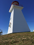
Baccaro Point Lighthouse
Baccaro Point B0W 1E0
Perched on the edge of the ocean, this lighthouse is an important bird watching site. Located on the east side of Barrington Bay near Port La Tour, this small wooden lighthouse was built in 1934. It replaced the original building that was built in 1850, which was destroyed by fire. Baccaro is the oldest place name in Nova Scotia. It comes from the Basque word "bacolao", which means codfish. Baccaro point is the southernmost point of mainland Nova Scotia. (Cape Sable, on Cape Sable Island, is the furthest south.) In 1852, the materials for the first lighthouse were hauled along the beach, since there was no road leading to it. Today, the 45-foot tall, square, tapered building stands fast on its bed of solid rock. Accessible by land.
Bon Portage Island Lighthouse
Shag Harbour
The Bon Portage Island lighthouse was established in 1874. For 110 years, 16 principal lightkeepers and their families kept the light burning on this small, windswept island. The longest serving keeper was Morrill Richardson, who along with his wife Evelyn, bought the island (except for the lighthouse property) in 1929. In 1945, Evelyn Richardson's classic book “We Keep A Light” was published and quickly became a best-seller in Canada. She described her family's life on the island with sensitivity and humour, noting both the disadvantages and joys of life on an isolated island. Bon Portage Lighthouse was replaced in 1964 by the current building. Accessible only by boat.
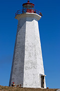
Cape Negro Lighthouse
Cape Negro B0W 3N0
Located on the southeastern end of the island, the 91 foot high structure has a light range of 16 miles. Originally built in 1872, the current tower replaced it in 1915 and was automated in 1993. Cape Negro was named on Champlain's map of 1612. In his book, The Works of Samuel de Champlain, Volume 1, Champlain wrote, "Proceeding along the coast we reached a very good port for vessels, and the head of which is a little river extending a good way inland. I named this the harbour of Cape Negro, on account of a rock which from a distance looks like one..."
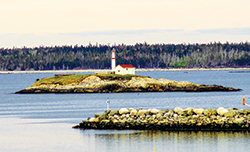
Cape Roseway Lighthouse
Shelburne
Established in 1788 on McNutt's Island at the mouth of Shelburne Harbour, Cape Roseway was the third lighthouse built in Canada. It was built old world style with the cliff rocks it stands on. The rock walls were 6 feet thick and were structured with oak beams. In 1959, the lighthouse was struck by lightning and burned. The rock slabs were cracked and were replaced by the current concrete tower. The Present light is 111 feet above sea level. Today the light is accessible by boat and a two mile road from the wharf. Take a Shelburne Harbour Boat Tour and spend the day exploring McNutt's Island. A great location for geocaching, historic sites, hiking trails and bird watching.
Cape Sable Island Lighthouse
Barrington
Located on the southernmost tip of Atlantic Canada, the Cape Sable Lighthouse, originally built in 1861, is the tallest lighthouse in the Maritimes at 101 feet. The station was de-staffed in 1986. It is only accessible by boat, but there is a magnificent view from the beach at the end of The Hawk Road, located on Cape Sable Island.
The lighthouse is not open to the public,but visitors can explore the exterior and surrounding area. This area is also designated as an Important Bird Area. On July 28, 1989, the Federal Heritage Building Review Office designated the Cape Sable Light tower a Classified Building, thereby ensuring it the highest level of ongoing protection.
Carter's Lighthouse
Lockeport
Located 0.4 miles north of Cranberry Island in the approach to Lockeport’s Harbour, Carter's Island Light is best viewed from the end of South Street in the Town of Lockeport. The lighthouse was originally built and lit in 1872 then replaced in 1989 with its present day 30 foot circular tower.
Charlesville Lighthouse
Lower East Harbour, Barrington
The original Charlesville (Pubnico Harbour) Lighthouse was built in 1854. It was a white, square, pyramidal wooden tower with a red lantern, and a dwelling attached. Both were demolished in 1967 and replaced with a conical fibreglass tower. Accessible on land. Great spot for viewing the Pubnico Wind Farms and fishing boats in Pubnico Harbour.
Gull Rock Lighthouse
Lockeport
Stop by the Crescent Beach Centre at the entrance of the Town of Lockeport and view Gull Rock Lighthouse from their observation tower. It is located over 1 mile offshore. This square wooden structure was built in 1955 to replace the original tower of 1853.
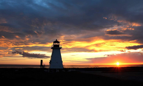
Sandy Point Lighthouse
1586 Sandy Point Road, Shelburne 902 875 2570
This attractive lighthouse, which originally was built on a pier, now sits on a crib at the east side of the entrance to Shelburne Harbour. The tower stands 44 feet tall and is a tapered square wooden structure that was built in 1873. Located on the shore, the area where the light keeper's house once stood, is a community centre and picnic area. Stop in at the canteen (open during the summer months) or attend one of the many events held at the community centre (festivals, community breakfasts, lobster suppers). Staff at the centre are happy to tell visitors about the history of the lighthouse and its keepers. At low tide, you can walk out to the tower on the sand bar - a great photo opportunity. From the beach, watch fishing boats, sailboats and container ships travelling in and out of the busy harbour. Sandy Point is also an excellent spot to see birds and spectacular sunsets.
Stoddard Island/Emerald Isle Lighthouse
Emerald Isle, Shag Harbour
Located in Shag Harbour, this square, wooden tower was built in 1877.Standing at 21 feet tall the station was de-staffed in 1993.
The Salvages Lighthouse
Cape Negro
The Salvages is a group of ledges and rocks on the west side of Cape Negro Harbour. In 1915, a diaphone was placed on the highest rock, which gave three blasts every minute to warn seafarers. In 1965 a 53 foot high white rectangular lighthouse was built. On a clear day, the station can be seen from Baccaro Point.